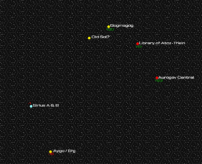
I've been asked before for a map of the Strange Stars. While I don't have a map of that whole area close to ready to share by any means, I was playing around with some hexographing software last night and was able to duplicate relatively quickly the part of the Zuran Expanse I've discussed on the blog. Since I tend to jump around a lot in my posts, even this area is a bit sparse.
The Zuran Expanse, you may recall, is a region of space in the Orion Arm of the Milky Way without central authority and containing many isolated or damaged worlds. It occupies territory that was once the nexus of human and transhuman civilization. That is until the event known as the Great Collapse.
The map is scaled to 1 hex=1 light-year, so distances are approximate. The numbers next to the stars are the z-axis. A plus and green color is above the galactic plane; a minus and red is below.
The location of Sol is speculative. This system is quarantined by posthuman entities, so its status as the origin of the human phyle can't be verified.
The map uses the names travelers would most likely use. Some are a planet (Gogmagog) or station (Aurogov or the Library), and others are legitimately the star pictured (Sirius). Many of the star names we use today will be lost by that time, though Eridanus (our 82 Eridani), the primary of Aygo of the zhmun, and Sirius (lair of the ssraad) endure.
3 hours ago


3 comments:
Very cool! I wish some kind soul would find me a copy of SPI's "Outreach" the ultimate Space Opera game for the only child. That is about the scale I need for the Empire (i.e., thousands of stars per hex).
Is this Hexographer? I was looking at the old map from SPI's Universe game. That's a lot of real estate. And a lot of empty space to map. I'm thinking of going the opposite direction and instead somehow plotting out proximity or access. Focus on mapping things that matter, and leaving the rest to random tables. We'll see if this goes anywhere. I still have a few more hexes to detail for Lithus.
I can see that, though that's really work diagramming then. You could replace any map with graphical notations of distances and important features. For me, there is something about seeing the lay of the land (or space) to give one a since of the physicality.
Post a Comment