Here's the map with some events labelled from my ongoing Planet of the Apes game. Of course, this old map contains cities and roads, none of which continue to exist in the 36th century.
This is a "work in progress map of the Azuran System, location of the Star Warriors setting I've done a couple of posts about. Some of these worlds have been mentioned in other posts, but here are the thumbnail descriptions of the others: Yvern: Humans share this tropical world with sauroid giants! They have learned how to domestic these creatures as beasts of burdens and engines of feudal warfare. Some Yvernians are able to telepathically communicate with their beasts.
Vrume: The desert hardpan and canyons of Vrume wouldn’t attract many visitors if it weren’t for the races—the most famous of these being the annual Draco Canyon Rally.
Zephyrado: Isolated by its “cactus patch” of killer satellites, Zephyrado is home to hard-bitten ranchers and homesteader colonists—and the desperados that prey on them!
Geludon: A windswept, frozen world, Geludon is home to mysterious “ice castles” built by a long vanished civilization and the shaggy, antennaed, anthropoid Meego.
Robomachia: A world at war! An all-female civilization is under constant assault from robots that carry captives away to hidden, underground bases--never to be seen again.
Darrklon: Covered by jagged peaks and volcanic badlands shrouded in perpetual twilight, Darrklon is a forbidding place, made even more so by its history as the powerbase of the Demons of the Dark. Few of the Demons remain, though their fane to Anti-Source of the Abyss still stands, and through it, they direct the Dark Star Knights and other cultists.
Computronia: A gigantic computer that managed the bureaucracy of the Old Alliance and served as its headquarters. It is now under the control of the Authority, and its vast computational powers are used to surveil the system.
Elysia: Elysia was once a near paradise. Technology and nature were held in balance, and its gleaming cities are as beautiful as its unspoiled wilderness. Elysia’s highest mountain was site of the training center of the Star Knights. Now, the Star Knights have been outlawed and the people of Elysia live in a police state imposed by the Authority.
Authority Prime: This hollowed out asteroid holds not only the central headquarters of Authority High Command, but its training academy and interrogation and detention center, as well.
This is a map of the Cloud Castle of Azurth and its environs by Arlin Ortiz. Here are some points of interest:
The Vitrified Forest, where lives a man with a very fancy hat. The Terrarium, giant-sized, as is everything in it. The Tower. where Zykloon, the Tornado Tyrant dwells. The Air Docks, where visitors once arrived to see the sights. The Lair of the Cloud Dragon, perhaps not forlorn, but lonely. A Cosmic Cat, curled upon a fallen star.
I've suggested turning Krypton into a locale for a weirdhexcrawl. In that vein, it seems only natural to utilize that little bit of Krypton on Earth, Superman's Fortress of Solitude as the site of a dungeon. It's a bit high tech, true, so it would work best in post-apocalyptic or science fantasy games. Here are the floor plans.
Overview.
Level 1 (note the "save or die" disintegration pit):
Level 2:
Level 3's exact floorplan is unrevealed. You'll have to work that one out yourself.
The image at the top of the post is a conceptualization of the Fortress from a later era, but it gives some nice imagery for various rooms or areas.
Rann, as originally appearing in Showcase #17 (1958) is in the Alpha Centauri system. It's home to an advanced civilization reminiscent of advanced civilizations throughout planetary romance--which is to say advanced in some ways but without a lot of infrastructure to get in the way of adventuring. The person doing the adventuring in this case is Adam Strange, archaeologist from Earth who is brought to Rann by the Zeta Beam, ostensibly an attempt at communication (though Alan Moore suggests its creator had teleportation in mind all along).
Though Adam Strange had a good run in his early adventures and has been brought back for later series, all this traversing of Rannian geography has never been accompanied by a map. Jack C. Harris addressed that lack in The Amazing World of DC Comics #8 (1974):
Harris scoured Adam Strange's appearances to get all the details:
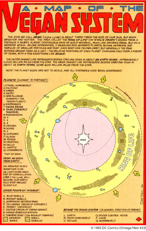
The setting for DC Comics Omega Men. The links here will take you to detail about some of the locations, but of course, it might be much more game-useful to make up your own details.
The map above by Gus L of The Dungeon of Signs is of the Country of Yanth in the Land of Azurth. Gus has faithfully reproduced the style of the Orrey Blundur, Royal Cartographer to King Cyan of Azurth. As is custom following the Bichromatic Compromise, the Country of Yanth is colored yellow. Mundy was a practitioner of artistic cartography, favoring a aesthetically pleasing arrangement of feature over accurate representation. The geography of Azurth has never been quite as settled as it is in other lands, so this is perhaps not as great a failing as it might seem.
Blundur is rumored to have disappeared into a trap street he inserted into a map of the Sapphire City the week before, then subsequently discovered in the real world.
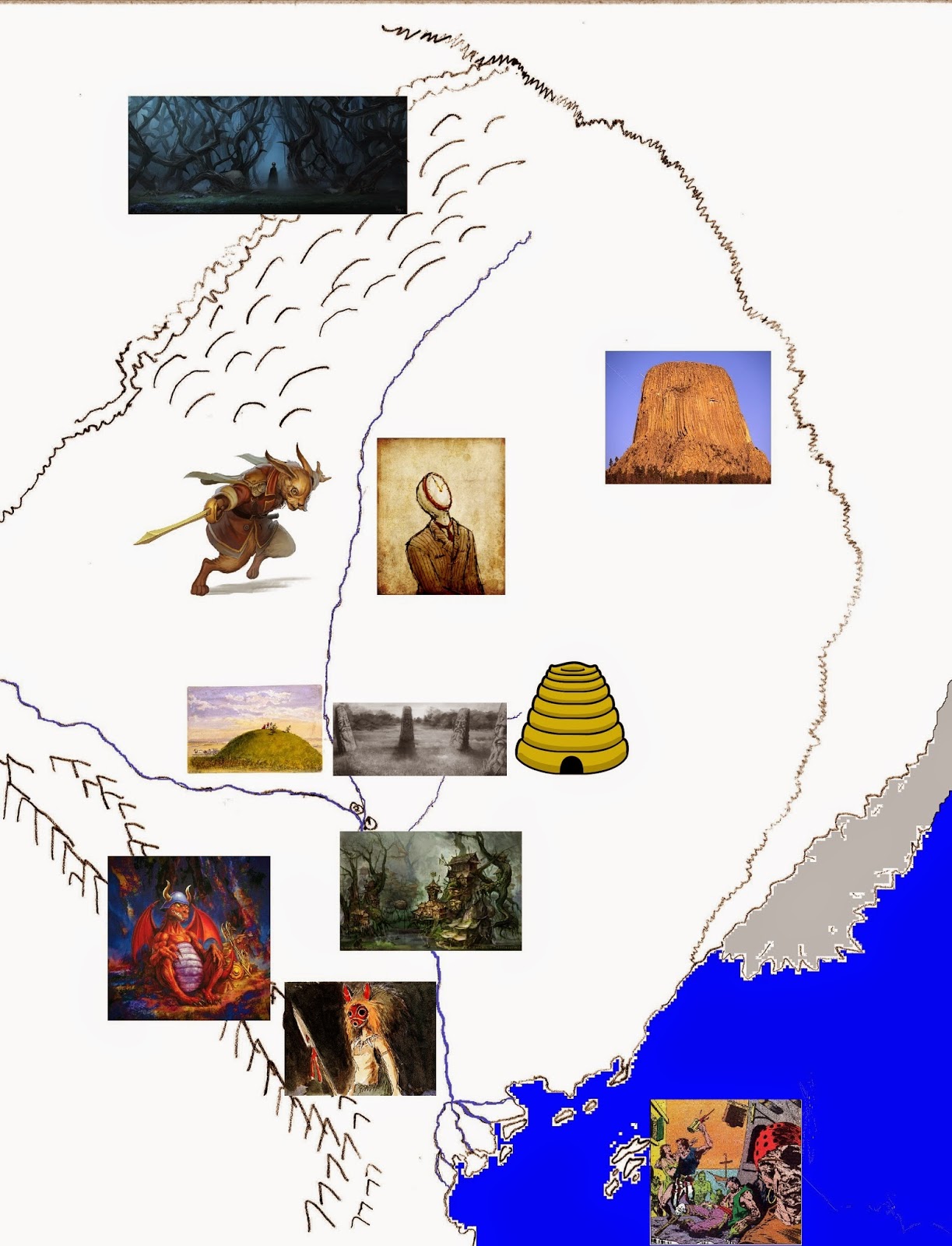
I've been trying to but together a map so I can send notes off to Gus L of the Dungeon of Signs to get a map like this cool ASE one he did. Mainly, I just seem to be adding now locales and not getting much drawing done.
So far we've got:
The Vale of Thorns
The Warrens of the Rabbit Folk
Horologopolis
Mount Brawl
The Mounds of the Ancients
The Great Standing Stone Sages
Apiaria, the Hive City of the Bee Folk
Lardafa, the Shanty-City of the Swamps
The Elder Dragon
Aldwode Forest
The Motley Isles
Some of these places I've talked about before, but the pictures will have to serve for the rest at the moment.
Or at least all the places California gets to be in the movies. The above is a 1927 Paramount Films map of potential shooting locations in Southern California. This next one is locations within the Alabama Hills were films were actually shot:
Now, I'm not sure exactly how one might use this information to make a setting from the terrain of Southern California, but I'm sure it's possible.
Coming just in time for the resumption (at least for one more session) of my long hiatused Weird Adventures game this Sunday, Lester B. Portly unveiled on G+ this map of Empire Island with the neighborhood key arranged in alphabetical order. Handy!
Hospitals are marked with red crosses, but I would warn user that this information is for planning purposes only and may not reflect the current location of medical facilities. For instance, Aldwood (consumed as it is by a fictional reality) doesn't have an accessible hospital.
Looking around for cool fantasy maps, I've come across of number of maps of fairytales/folklore/myth. They don't have any hexes (though that could be remedied), but they've got all the encounters laid out right their for you.
Probably the biggest and best of these is Bernard Sleigh's "Ancient Map of Fairyland." It's really big, but you can peruse it and soak up all its detail here. If that's too much here's the slightly less detailed Jaro Hess map of the "The Land of Make Believe":
The writing is small there, but this blog post runs down a list of all the points.
Saving the easiest to read (and most modern) for last, here's a map by Walt Kelly of Pogo fame:
Is He-Man's Eternia the future or past of our own world? This map super-imposing the two hints that their only a cataclysm apart, one direction or the other. Something like a run away comet hurtling between the earth and the moon, perhaps?
Someone should do a comparison map with She-Ra's Etheria:
I wanted something in the mode of several old comic book maps, and this is just about perfect, Future posts will give details of some of the locations, but right now bask in the mystery!
I've been asked before for a map of the Strange Stars. While I don't have a map of that whole area close to ready to share by any means, I was playing around with some hexographing software last night and was able to duplicate relatively quickly the part of the Zuran Expanse I've discussed on the blog. Since I tend to jump around a lot in my posts, even this area is a bit sparse.
The Zuran Expanse, you may recall, is a region of space in the Orion Arm of the Milky Way without central authority and containing many isolated or damaged worlds. It occupies territory that was once the nexus of human and transhuman civilization. That is until the event known as the Great Collapse.
The map is scaled to 1 hex=1 light-year, so distances are approximate. The numbers next to the stars are the z-axis. A plus and green color is above the galactic plane; a minus and red is below.
The location of Sol is speculative. This system is quarantined by posthuman entities, so its status as the origin of the human phyle can't be verified.
The map uses the names travelers would most likely use. Some are a planet (Gogmagog) or station (Aurogov or the Library), and others are legitimately the star pictured (Sirius). Many of the star names we use today will be lost by that time, though Eridanus (our 82 Eridani), the primary of Aygo of the zhmun, and Sirius (lair of the ssraad) endure.
Work has been grueling this week! More of my regular posting content is forthcoming, but for now enjoy another map. This one is from Don Lawrence's Trigan Empire. Marvel at its mysteriousness!
This map from Amethyst: Princess of Gemworld throws realism completely out the window. In later stories, Gemworld becomes an actual planet. I think this was better.
Here's some details about Gemworld and points of interest.